

Price
USD 999
Trip Reviews
25 Reviews
Trip Duration
14 Days
Trip Grade
Challenging
Highest Altitude
5,416 m
Accommodation
Hotels and Teahouse lodges
Transportation
Car/Jeep
Group Size
15 max
Best Season
Spring and Autumn
Annapurna Circuit Trek Brief Insight
The Annapurna Circuit Trek Journey is an iconic and physically demanding trek through alpine beauty and adventure. The circuit has become one of the world’s most popular trekking destinations. It is the longest trail in the Annapurna region.
The Annapurna Circuit Trek follows the trail across the Himalayan highlands of central Nepal. The hike leads to a community populated by Gurung, Manangi, and Thakali people. The Tibetan style is used to construct the majority of the homes in the Annapurna region. In this area, you won’t have any trouble discovering a place to stay. The beautiful scenery and cultural richness of this voyage are well-known.
It is well worth the time and effort of overcoming challenges and walking in the Annapurna Circuit. To complete this demanding trek, one must have a basic fitness level. The Annapurna Circuit Trek is notable for its vistas, hot springs, and deep stunning canyons, among other things. The picturesque topography of the Annapurna Circuit is shelter to a wide variety of animals, including snow leopards, blue sheep, and other species.
The trek introduces you to amazing places including PoonHill, Thorang La Pass, Muktinath Temple, and more. You also can enjoy a day in Pokhara after concluding the trek. The Annapurna Circuit Trek requires between 12 and 20 days to complete, based on how many destinations you add to the circuit. You will be trekking for 5 to 7 hours per day on average.
Highlights of Annapurna Circuit Trek
- A spectacular traditional trek awaits you in Nepal’s northwest region.
- The attractions include hot springs, Buddhist and Hindu temples, charming rural settlements, and stunning vistas of the Annapurna ranges, to name a few.
- Learn about the lives of many ethnic groups, such as the Gurung and Thakali.
- The Annapurna Conservation Area’s flora and fauna are utterly gorgeous.
- Witness the world’s highest lake-Tilicho Lake (4,919m).
- Enchanting view of Annapurna and Dhaulagiri from the Annapurna Base Camp.
- The Manang district is surrounded by mountain ranges such as Mt. Peru, Manaslu, Muktinath, and many others.
- Visit a variety of monasteries and temples while relaxing in a natural hot spring.
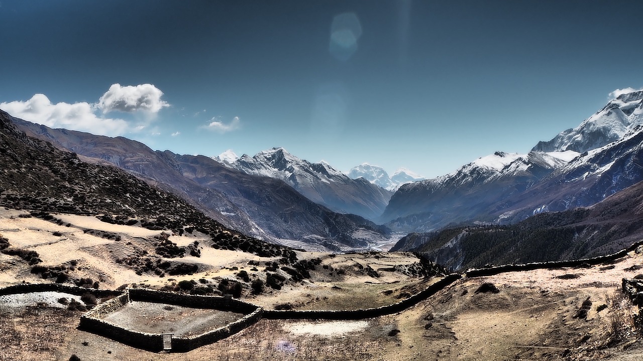
Gallery of Annapurna Circuit Trek
Outline Itinerary
- Day 01: Drive from Kathmandu to Bhulbhule
- Day 02: Trek from Bhulbhule to Jagat
- Day 03: Trek from Jagat to Dharapani
- Day 04: Trek from Dharapani to Chame
- Day 05: Trek from Chame to Pisang
- Day 06: Trek from Pisang to Manang
- Day 07: Acclimatization day at Manang
- Day 08: Trek from Manang to Yak Kharka
- Day 09: Trek from Yak Kharka to Thorong Phedi
- Day 10: Trek from Thorong Phedi to Muktinath Temple
- Day 11: Drive from Muktinath to Tatopani
- Day 12: Trek from Tatopani to Ghorepani
- Day 13: Morning hike to Poon Hill - then trek to Birethanti and Drive to Pokhara
- Day 14: Drive from Pokhara to Kathmandu
Detailed Itinerary
Day 01: Drive from Kathmandu to Bhulbhule
Highest Altitude :
Bhulbhule (845m / 2,815ft)
Trek Duration :
7-8 hrs.
The journey initiates with a drive from Kathmandu in the early hours of the day. The drive to Bhulbhule comprises picturesque scenery.
The Trishuli River flows next to the Kathmandu-Pokhara highway. The trek then continues north of Besisahar until it reaches Bhulbhule. You’ll be amazed by the magniicent views of a lush green slope, snow-capped mountains, colorful terraced fields, and tiny settlements along the way.
Day 02: Trek from Bhulbhule to Jagat
Highest Altitude :
Jagat
Trek Duration :
6-7 hrs.
The actual hike begins on the second day. You’ll go through lush forest and terraced farmland along a beautiful path. The trail follows the Marsyangdi River until arriving in Jagat, traversing through several local villages.And hence you’ll arrive in Jagat on continuing the trek.
Day 03: Trek from Jagat to Dharapani
Trek Distance :
15km
Highest Altitude :
Dharapani (1,860m / 6,200ft)
Trek Duration :
6-7 hrs.
Begin the hike in the early morning hours. The first part of the journey is on hilly terrain that often climbs and falls. The trail follows rocky paths across green fields, crossing a few suspension bridges along the way.
After a brief hike, you will arrive at the beautiful valley of Manang district. Along the route, you may see the farming methods of people living in the Himalayan highlands. Despite the land’s low yield, you’ll find barley, potatoes, corn, and cattle sheds that are suitable for the high altitude. You can also enjoy the gorgeous sight of rhododendrons and bamboo forests in the region. Finally, you’ll arrive in Dharapani.
Day 04: Trek from Dharapani to Chame
Trek Distance :
15.5 km
Highest Altitude :
Chame (2,610m /8,890ft)
Trek Duration :
6-7 hrs
The path to Chame passes through dense forests of pine, fir, oak, and mapple. After leaving Dharapani, you travel along the Marsyangdi River.
The trail approaches steep slopes where multiple landslides may be seen due to geological issues and the construction of a road to Manang Mustang. The stunning vistas of Lamjung Himal, Annapurna II, and Annapurna IV up close is astonishing on the route.
The Dudh Khola and the Marshyangdi River are encircled by a few regular and breathtaking waterfalls that will cause you to disregard the challenges you had on your walk. If you keep going, you’ll ultimately reach Chame. Chame is the district headquarters for Manang district.
Day 05: Trek from Chame to Pisang
Trek Distance :
13.2 km
Highest Altitude :
Pisang (3,115m / 10,200ft)
Trek Duration :
5-6 hrs.
On heading out Chame, the trek continues past the city’s historic district and up to Telekhu, at an elevation of 2840 meters. You’ll get your first peek of the gorgeous Paungda Danda rock face after turning a corner on the trek. It’s a massive curving granite slab rising 1500 meters above the river.
The routes provide clear views of Annapurna II in the south and Pisang Peak in the northeast. After that, the path descends to the bottom of the Manang Valley, where you will spend the night in Pisang village.
Day 06: Trek from Pisang to Manang
Trek Distance :
17 km
Highest Altitude :
Manang (3,540m / 11,300ft)
Trek Duration :
5-6 hrs
Today you’ll be traveling to Manang. Over time, the quest will make its way to Bryaga. It is a Tibetan-style village that follows the valley bottom at 3500 meters. Houses in Bryaga are piled one on top of the other, each with an open veranda made by the roof of a neighbour. The gompa is built on a rock above the settlement. It is the district’s most visible structure adorned with numerous statues. Continue on until you reach Manang bazaar, where you will travel by additional monasteries.
Day 07: Acclimatization day at Manang
Highest Altitude :
Manang (3,519m / 11,545ft)
Trek Duration :
3-4 hrs
In order to acclimatize to the greater altitude, you’ll spend the day exploring Manang. Hikes up to Gangapurna Lake and Base Camp in the early morning reward you with exquisite views of Annapurna III, Pisang, Tilicho, and Chulu Peaks. Aside from it, Manang Village and the Monasteries are worth visiting.
Manang village is surrounded by beautiful scenery. You can view more of the surrounding mountains and the Gangapurna glacier as you gain altitude. Take a seat and absorb everything for a moment.
Day 08: Trek from Manang to Yak Kharka
Trek Distance :
10 km
Highest Altitude :
Yak Kharka (4,050m / 14,275ft)
Trek Duration :
5-6 hrs
After acclimating for a day in and around Manang, you climb to Yak Kharka. The climb from Manang to Yak Kharka is 10 kilometers long and takes 5 hours to complete, with an elevation gain of 510 m. You’ll walk through a juniper forest and several pastures.
As the hike progresses, you will pass through Gunsan, a small town with flat mud roofed houses. There will also be yak and horse pastures to see. Following a wooden bridge crossing of a small river, you’ll make your way up the lovely valley to Yak Kharka, an open, peaceful meadow. It will be a rise to 4100m from 3540m by the end of the day.
Day 09: Trek from Yak Kharka to Thorong Phedi
Trek Distance :
8.5 km
Highest Altitude :
Thorong Phedi (4,525m / 14,525ft)
Trek Duration :
5-6 hrs.
In the wake of leaving Yak Kharka, you’ll move to an edge. Then, at that point, make your way down to the Marsyangdi’s headwaters and cross the waterway on a covered wooden bridge.The path descends to Thorung Phedi by a little trail across a slope after ascending the mountain.
Day 10: Trek from Thorong Phedi to Muktinath Temple
Trek Distance :
15.6 km
Highest Altitude :
Thorong La Pass (5,416m / 17,756ft)
Trek Duration :
8-9 hrs.
On this day, the trip continues across the Thorang La Pass from Thorong Phedi to Muktinath Temple.
The trail ahead is 5416 meters high. Consequently, you may be exposed to strong winds if you show up late. Locals have used this trail to bring sheep and yaks into and out of Manang for hundreds of years. As a consequence, the path is well-defined and easy to follow, despite the fact that it is frequently steep.
The Thorung La pass, which is adorned with traditional prayer flags and a stone monument, provides fantastic view. The Annapurnas, Gangapurna, and Khatung Kang, a glaciated mountain, can all be seen.
You’ll have to stroll through beautiful fields and across meadows to get to Muktinath temple. The 108 stone sprouts that emerge water from the Kaligandaki River are the most significant aspect of Muktinath Temple. According to tradition, visiting the Temple, which is a sacred Hindu and Buddhist pilgrimage site, will rid you of all your sorrows.
Day 11: Drive from Muktinath to Tatopani
Trek Distance :
113km
Highest Altitude :
Tatopani (1,200m / 3,940ft)
Trek Duration :
6-7 hrs.
The days of strenuous hiking are over, and the trails are totally flat. As you go down the Kaligandaki River to Jomsom, the trekking trail continues to descend to the Ekle Bhatti and then smooths out. In contrary to everything else seen on this journey thus far, Jomsom is a thriving town. The Manang district’s capital is Jomsom.
You’ll travel across barren mountains and gorgeous verdant forests. Tatopani is known for its natural hot springs, which you can immerse yourself in to relax. The pristine waters of Tatopani are said to have anti-inflammatory and anti-fungal properties.
Day 12: Trek from Tatopani to Ghorepani
Trek Distance :
17 km
Highest Altitude :
Ghorepani (2,860m / 9,385ft)
Trek Duration :
6-7 hrs.
Today you’ll be leaving the hot springs behind and travel to Ghorepani through Sikha and Chitre, two ethnic Thakali communities on the east bank of the Kali Gandaki River. The trail passes through magnificent rhododendron, birch, and magnolia forests, as well as terraced farmlands surrounded by mountains. You’ll spend the night at Ghorepani, a lovely town perched atop a ridge.
Day 13: Morning hike to Poon Hill - then trek to Birethanti and Drive to Pokhara
Trek Distance :
12.5km
Highest Altitude :
Poon Hill (3,210m / 10,525ft)
Trek Duration :
4-5 hrs.
Hike up to Poon Hill (3,210m) this morning for a sunrise vista of Mt Machhapuchhre as well as the Annapurna and Dhaulagiri massifs. Poon Hill is perhaps the most well-known photographic locations due to its scenic beauty. You can take photographs to commemorate the event. Breakfast will be served at the Ghorepani resort after that. You’ll hike to Birethanti after breakfast and then drive to Pokhara.
Day 14: Drive from Pokhara to Kathmandu
Trek Distance :
200 km
Highest Altitude :
Kathmandu (1,350m / 4,450ft)
Trek Duration :
6-7hrs
The Annapurna Circuit Trek has reached its conclusion. After breakfast in Pokhara, a tourist bus will take you back to Kathmandu. It’s a 200-kilometer journey that begins with the Marsyangdi River and ends with the Trishuli River. On the other hand, you can fly directly to Kathmandu.
Best Time for Annapurna Circuit Trek
Despite the fact that the trekking trails in Nepal are open the entire year, the best seasons to go for an Annapurna Circuit Trek are as per the following:
Autumn (September to November)
During the time of autumn, the days are warm, but the evenings are typically breathtaking. This season provides you with a wonderful setting in which to explore. Trekkers often use this trail during the autumn season. The stunning mountain vista is amazing at this time of year.
Spring (March to May)
The Annapurna Circuit Trek is additionally best done in the springtime. The strolls are loaded up with rhododendrons and different blossoms in the spring. The weather conditions is light and the sights are clear and apparent. It is less congested than autumn, while being the second best season for trekking.
Accommodation and Meals
In the Annapurna region, the number of tea houses and facilities has expanded. This is due to the Annapurna Circuit Trek’s popularity among trekkers.
Tea houses are the main source of lodging all through the Annapurna Circuit Trek. As we rise, the standard and requirements of tea houses degrade. The tea houses here mostly include rooms with two beds each. But as you get nearer, you may not be able to find single accommodations. Hot water for showers is given until you reach Manang; after that, the amenities degrade, and you just might have to pay for hot showers.
The meal is excellent during the walk. It becomes more costlier as you continue climbing in elevation. Traditional Nepali food (daal, bhat, and tarkari) is available throughout the ascent, and you might obtain some bread and jams for breakfast in the top elevations. Extra items, such as chips and cold drinks, may be more pricey in this region.
Packing list for Annapurna Circuit Trek
Here is the list of trekking gears and equipment necessary for the Annapurna Circuit Trek:
Essentials
- All-season sleeping bag
- Duffel bag
- Down jacket
- Daypack
Upper Body
- Sun hat or cap
- Woolen hat
- UV protection sun hat
- Mufflers
- Headlamp
Main Body
- Thermal wears
- T-shirts
- Fabric jacket (Wind/waterproof)
- Fleece Jacket
- Fabricated sports bras (for females)
Lower Body
- Thermal bottoms
- Normal pants
- Trousers (Wind/waterproof)
- Trekking pants (soft shell and hard shell)
- Hiking shorts
Hand
- Smartwool liner gloves
- Hardshell gloves
Feet
- Warm socks
- Liner socks
- Trekking boots
- Casual shoes
- Gaiters (for extreme cold)
First Aid Kits and Medications
- Sunscreen
- Lip balm
- Antibiotic ointment
- Bandages
- 125 or 250 mg Acetazolamide tablets for altitude sickness
- Painkiller tablets
- Pepto Bismol for indigestion or diarrhea
Extras
- Powerbank or extra batteries
- Cameras and mobile phones
- Binoculars
- Pee bottle
- Trekking sticks
- Whistleblower
Dates of Trip
PRICE
DEPARTURE DATE
TRIP STATUS
Frequently Asked Questions
Is it possible to get altitude sickness when traveling at a high altitude?
Altitude sickness is a possibility because the Annapurna Circuit is a high-altitude trek. The trek starts at 1000 meters and ascends to 5416 meters at Thorong La Pass. Everyone reacts to the altitude differently, regardless of how athletic or experienced a trekker they are.
When is the best time for this trek?
Annapurna Circuit Trekking is typically enjoyed in the autumn (September to November) and spring (March to May). The days are sunny and bright, with cloudless blue skies. Due to this , you'll be able to see the Annapurna and Dhaulagiri summits in all their magnificence.
For the Annapurna Circuit Trek, what permits and entries are required?
Except for Nepali citizens, trekkers must obtain the following authorization to complete the Annapurna Circuit Trek:
The Trekkers Information Management System (TIMS) costs Rs. 600 for SAARC member countries and Rs. 2000 for non-member countries. For SAARC members, the Annapurna Conservation Area Permit (ACAP) costs Rs. 200, and for non-members, it costs Rs. 2000. You can also get this permit at Besisahar before you commence your travel.
The Nepal Tourism Board offices in Pokhara and Kathmandu can issue permits.
Is prior trekking experience required to participate in the Annapurna Circuit Trek?
No prior trekking experience is required for the Annapurna Circuit Trek. Since this trek is physically demanding, it's crucial to be physically and mentally strong.
Is trekking the Annapurna Circuit appropriate for people of all ages?
There is no age requirement for the Annapurna Circuit trek, however you need to be in decent shape and have a strong mindset. It is highly recommended that you see your doctor before going on the trip to get the required permissions and instructions, as well as high-altitude travel meds.
Trip Downloads
You May Also Like

Mera Peak Climbing
17 days
From$ 999
From dream-like lakes to a distinctive culture based on age-old traditions and etiquette,it's no surprise that Annapurna camp is a source


Everest Base Camp Trek
12 Days
From$ 999
From dream-like lakes to a distinctive culture based on age-old traditions and etiquette,it's no surprise that Annapurna camp is a source

Everest Expedition
58 days
From$ 999
From dream-like lakes to a distinctive culture based on age-old traditions and etiquette,it's no surprise that Annapurna camp is a source

Annapurna Circuit Trek
14 Days
From$ 999
From dream-like lakes to a distinctive culture based on age-old traditions and etiquette,it's no surprise that Annapurna camp is a source